")
Key Takeaways
- Scientists have mapped a hidden world of mountains and valleys larger than Belgium under the Antarctic ice.
- The landscape, shaped by ancient rivers over 34 million years ago, has been preserved under ice up to two miles thick.
- This discovery is vital for predicting how Antarctica’s ice will respond to climate change.
Scientists have uncovered a massive, ancient landscape of mountains and valleys buried deep beneath the Antarctic ice sheet. This hidden world, revealed through radar surveys, could change our fundamental understanding of the frozen continent.
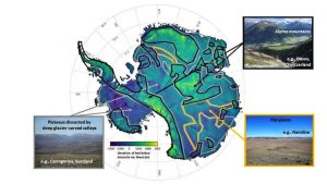
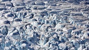
The terrain, frozen for millions of years, is larger than Belgium. It was mapped using ice-penetrating radar from aircraft flying over East Antarctica.
An Ancient World Revealed
Researchers from the University of Edinburgh and the British Antarctic Survey led the study. Radar signals bounced off the bedrock, charting a dramatic world of sharp peaks and deep valleys covering roughly 32,000 square kilometres.
This landscape was likely carved by rivers long before the East Antarctic Ice Sheet formed around 34 million years ago. It has been preserved under ice nearly two miles thick.
“It is an undiscovered landscape — no one’s laid eyes on it,” said Professor Stewart Jamieson, a glaciologist at Durham University. “What is exciting is that it’s been hiding in plain sight.”
Why This Discovery Matters for Climate Science
Published in Nature Communications, the find is more than a geological wonder. Understanding this preserved terrain is crucial for predicting Antarctica’s response to climate change.
The shape of the land beneath controls ice flow. Some newly discovered features could potentially accelerate melting if warming seawater reaches them.
“The land underneath the ice sheet is not just a blank canvas; it’s a complex and beautiful landscape that tells us a lot about the history of the ice,” said Dr. Neil Ross of Newcastle University.
This map is a key piece for modelling the ice sheet’s past and future, offering vital clues for .

