")
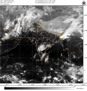
India is heading into a period of intense and unusual weather contrasts, with extreme rainfall lashing one part of the country while severe heatwave conditions grip another.
Meteorologists warn that this is not an isolated event but part of a broader phase of nationwide atmospheric instability likely to persist over the coming weeks.
The sharpest contrast is visible between Northeast India and the northern plains. States such as Arunachal Pradesh, Assam, Meghalaya, and Tripura are expected to witness sustained heavy rainfall over the next 10-14 days, raising serious concerns of flooding and disruption.
“Moisture flowing in from the Bay of Bengal, combined with passing Western Disturbances, is fueling continuous cloud formation and intense precipitation across the region,” said Devendra Tripathi, founder of Mausam Tak.
At the same time, large parts of northwest, central, and eastern India are battling rising temperatures.
The India Meteorological Department has warned that heatwave conditions are likely to prevail in isolated pockets over the next few days, with temperatures already climbing to abnormal levels in states such as Rajasthan, Delhi, Haryana, Madhya Pradesh, and Uttar Pradesh.
THUNDERSTORMS TO ROAR LOUD
Adding to the complexity is a wave of pre-monsoon thunderstorm activity expected across much of the country before early May.
Regions including Kerala, Karnataka, Maharashtra, Telangana, Odisha, Andhra Pradesh, West Bengal, and Bihar are likely to experience sudden storms accompanied by lightning, gusty winds, and localized flooding.
Wind speeds could reach up to 70 kmph in some areas, with the possibility of hailstorms in central India.

WHY IS INDIAN WEATHER UNSTABLE?
The larger global climatic shifts is a key driver behind these extremes.
According to Devendra Tripathi, rising sea surface temperatures in the Pacific Ocean and a transition from La Nina to ENSO-neutral conditions could pave the way for El Nino development around the monsoon season. This, in turn, may intensify heatwaves, particularly across northern India.
El Nio and La Nia are opposite phases of the climate cycle in the Pacific Ocean. El Nio warms ocean waters, often bringing hotter, drier conditions to India. La Nia cools waters, typically enhancing monsoon rainfall. Both disrupt global weather patterns, influencing heatwaves, storms, and seasonal climate variability worldwide.
Another contributing factor is the significant reduction in snow cover across Eurasia, including the Himalayas. With an 18% drop in snow cover earlier this year, less sunlight is being reflected back into space, accelerating warming trends both regionally and globally.
The impact is already visible. More than half of the world’s 50 hottest cities are currently in India, pointing to the severity of the heatwave conditions.
Meanwhile, increased surface heating is pulling moisture from the Arabian Sea and eastern regions, triggering unstable weather patterns and scattered rainfall across central and southern India.
Experts say the coming 10-15 days will be particularly challenging, as India grapples with this dual threat of floods and heatwaves.
While some northern regions may see brief relief from isolated rain later this month, overall conditions are expected to remain volatile.
As climate variability intensifies, India’s weather is increasingly defined by extremes, where rain and heat no longer follow predictable patterns, but collide in dramatic and potentially dangerous ways.

