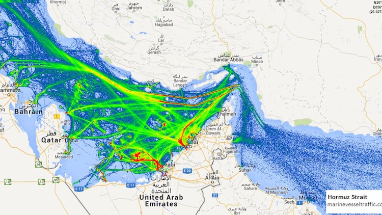
Satellite images reveal massive tanker jam in Strait of Hormuz: What caused it?

The Strait of Hormuz, a sea passage between Iran and Oman, is currently facing a massive digital blackout as sophisticated GPS jamming creates a chaotic tanker jam in one of the world’s most vital oil chokepoints.

Following joint US and Israeli military strikes on Iran under Operation Epic Fury on February 28, the region has transformed into an electronic battlefield.

While the waterway typically handles 20 per cent of the global oil supply, ship traffic has plummeted as vessels struggle to navigate through a dense fog of spoofed signals.

Captains report that their navigation systems are showing false positions, making it look as though massive tankers are sailing over dry land or are anchored at international airports.

WHY IS THERE A HUGE TANKER JAM IN THE STRAIT OF HORMUZ?

To understand this chaos, we must look at how ships find their way using satellite signals. They rely on the Global Positioning System (GPS) for location and the Automatic Identification System (AIS) to signal their position to others.

In the Strait of Hormuz, these signals are being attacked in two ways.

First is jamming, where a ground station blasts out high-power radio noise that drowns out the weak signals from satellites, like a loud siren masking a whisper.

A satellite view of the Strait of Hormuz where a massive tanker jam has formed due to intense GPS jamming. (Photo: marinevesseltraffic.com)

A satellite view of the Strait of Hormuz where a massive tanker jam has formed due to intense GPS jamming. (Photo: marinevesseltraffic.com)

Second is spoofing, which is more deceptive. Instead of blocking satellite signals, it sends fake coordinates that look legitimate to the ship’s computer.

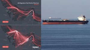
According to data from the maritime tracking firm Kpler, the digital footprints or tracks that ships leave on a map suddenly fanned out in erratic patterns on February 28.

These tracks, which usually look like smooth, straight lines, began jumping wildly as navigation receivers were overwhelmed by synthetic signals.

WHICH TECHNOLOGY IS IRAN USING FOR ELECTRONIC DEFENCE?

Iranian forces are using indigenous electronic warfare systems to create an invisible shield over the Persian Gulf.

The Iranian military has deployed the Cobra V8 and Sayyad-4 systems near Bandar Abbas.

The Cobra V8 is a truck-based platform designed to intercept and jam airborne radar and satellite signals within a 250-kilometre range.

While the Sayyad-4 is primarily known as a missile system, its specialised radar components are being used in a non-kinetic role to disrupt foreign navigation signals.

Kpler tracking maps show smooth ship routes on February 27 turning into chaotic pink lines by February 28 due to signal spoofing. (Photo: X/@kpler)

Kpler tracking maps show smooth ship routes on February 27 turning into chaotic pink lines by February 28 due to signal spoofing. (Photo: X/@kpler)

International maritime security analysts say that the goal is to blind the high-tech sensors and AI-driven guidance systems used by foreign forces during Operation Epic Fury.

While this technology is intended to hide warships and confuse incoming missiles, it has created a massive electronic blackout.

Over 1,100 civilian tankers are now caught in this digital fog, making the narrow 33-km-wide strait nearly impossible to navigate safely.

HOW DOES THIS BLACKOUT AFFECT SHIP SAFETY?

Satellite navigation failures in crowded waters increase the risk of maritime collisions exponentially. Large tankers carrying millions of barrels of crude oil cannot stop or turn quickly.

Without reliable data, crews must rely on manual radar and visual bearings, which significantly slows down global energy flows. This digital blockade is already having a real-world impact on seafarers.

Huge tankers are currently anchored in the Gulf of Persia as electronic interference makes the narrow waterway too dangerous to navigate using satellite data. (Photo: AP)

Huge tankers are currently anchored in the Gulf of Persia as electronic interference makes the narrow waterway too dangerous to navigate using satellite data. (Photo: AP)

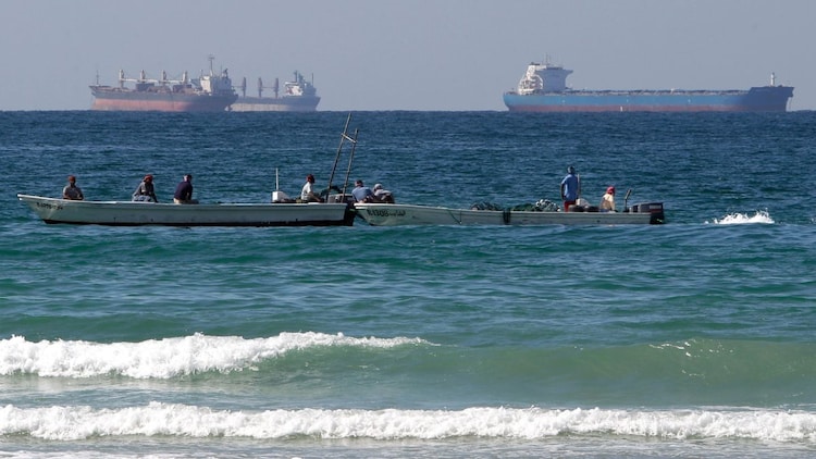
The tanker Skylight was struck near Oman on March 1, leading to the evacuation of its 20-member crew, which included 15 Indian nationals.

As modern shipping remains almost entirely dependent on electronic data, this crisis highlights how invisible radio waves can be used to hold the global economy hostage.

Latest

North to sizzle in heatwave, northeast to experience thunderous Wednesday

Temperatures across northwest and central India are expected to climb by another 3–5C before finally dipping towards the end of the month. But before that, he

Plants not just feel, they can hear the rain too, confirms new research

MIT scientists have discovered that rice seeds can sense the sound of rain and germinate up to 40 per cent faster as a result. The study reveals how sound waves

2026 could see a super El Nino and record-breaking global temperatures

La Niño is one of the phases of the El Niño–Southern Oscillation (ENSO) – a natural climate phenomenon. It usually occurs in the Pacific Ocean, influencin

Astronaut on Space Station captures rare comet flying over Earth. See pic

Nasa astronaut Chris Williams was photographing the Lyrid meteor shower from the Cupola aboard the International Space Station when he accidentally spotted a be

Dead zone in Akashganga: The region where Milky Way galaxy stops making new suns

Scientists have identified the precise edge of the Milky Way's star-forming disc by studying the ages of over 1,00,000 stars. The boundary sits roughly 35,000 t

Topics

Why the Iran conflict is taking a more dangerous turn

Stalled talks, ship seizures and nuclear disputes sharpen the Trump-Iran standoff

UP Board 12th Result 2026 today: Check last 5 years pass percentage trends

UP Board Class 12 results show steady improvement in student performance

JEE Advanced 2026 registration begins. Check direct link, eligibility and last date

The Indian Institute of Technology Roorkee has announced the registration schedule for JEE Advanced 2026. Eligible candidates can apply online from April 23 to

Karnataka SSLC Result 2026 declared: Direct link to check Class 10 scorecards, pass percentage here

Karnataka SSLC Result 2026 has been declared by the Karnataka School Examination and Assessment Board (KSEAB). Students who appeared for the Karnataka Class 10

CBSE Class 10 second board exam datesheet out for May 2026, check full schedule

The Central Board of Secondary Education (CBSE) has released the official datesheet for the Class 10 second board examinations 2026. The exams will be conducted

Karnataka SSLC Result 2026: 5 alternative ways to check scorecards

Karnataka SSLC Result 2026 will be released today at 12 pm for Class 10 students. Here are all the alternative ways to check your result quickly and without has

UP Board 10th, 12th Result 2026: Here’s how to download marksheet on DigiLocker

UP Board Results 2026 will be declared at 4 pm today for Class 10 and 12 students. Here’s a simple guide to download your marksheet via DigiLocker instantly.

Dr Reddy’s jumps nearly 7% as Sensex falls: Why is the pharma stock rising?

Shares of Dr Reddy’s Laboratories surged sharply on Thursday, bucking a weak broader market and emerging as one of the top gainers on the Nifty 50.
spot_img

Related Articles

Popular Categories

spot_imgspot_img