")
If you live in the Gangetic plains or the hills, May 5 was not a quiet day.
Strong thunderstorms with winds gusting between 50 and 90 kmph were recorded in Jharkhand, Bihar, Punjab, Uttarakhand, Uttar Pradesh, Gujarat, Rajasthan, and parts of West Bengal.
Hailstorms were reported across Madhya Pradesh, Bihar, Jammu & Kashmir, Himachal Pradesh, Uttarakhand, and East Uttar Pradesh and were enough to damage crops and rattle windows.

Heavy rain fell across Sub-Himalayan West Bengal, Sikkim, Gangetic West Bengal, Bihar, and Kerala.
The highest single-station rainfall was 10 cm each at Ponmalai in Tamil Nadu and two stations in Jalpaiguri, West Bengal.
Meanwhile, temperatures told a different story on the other end of the country.
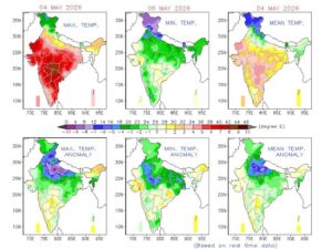
Brahmapuri in Vidarbha, Maharashtra, sizzled at a scorching 44.2°C, the highest maximum recorded anywhere in India on the day. The lowest minimum, on the other hand, was a relatively cool 16°C at Rajgarh in West Madhya Pradesh.

RAIN TO RETURN WEDNESDAY, STORMS TO PERSIST
Wednesday brings more of the same for several regions.
The India Meteorological Department (IMD), India’s national weather agency, which has been forecasting weather since 1875, expects heavy rainfall at isolated spots in Arunachal Pradesh, Assam & Meghalaya, Bihar, Kerala, Sub-Himalayan West Bengal & Sikkim, and Tamil Nadu & Puducherry.
Thunderstorms with gusty winds in the 40–50 kmph range are likely in parts of Andhra Pradesh, Chhattisgarh, East Uttar Pradesh, Jammu-Kashmir, Jharkhand, Kerala, Madhya Pradesh, Odisha, and Sub-Himalayan West Bengal & Sikkim.
Lighter storms with winds of 30–40 kmph are forecast for Andaman & Nicobar Islands, Assam & Meghalaya, East Rajasthan, Haryana-Chandigarh-Delhi, Himachal Pradesh, Punjab, Telangana, Uttarakhand, and West Uttar Pradesh.
Thundersqualls, which is the name given to sudden, violent wind bursts reaching 50–60 kmph, are expected over Bihar and Gangetic West Bengal.
Hot and humid conditions will persist along Andhra Pradesh’s coast and in Konkan & Goa.

A WARM, WET WEEK AHEAD
Zooming out, the IMD’s seven-day forecast shows Kerala as the most consistently rain-hit region in the country, expecting widespread to fairly widespread rainfall every single day through May 11.
Sub-Himalayan West Bengal, Sikkim, and the Northeast will also remain heavily active through mid-week before activity tapers off.
In contrast, much of Central and West India, including Gujarat, Saurashtra, and Vidarbha, will stay largely dry.
To make matters worse, the heat will build further.
Northwest India is expected to see maximum temperatures climb by 4–6°C through May 9. By May 9–11, heat wave conditions are likely in isolated pockets of West Rajasthan, where temperatures could cross 45°C. Gujarat and Konkan & Goa will face hot and humid conditions from May 9 onwards.
A fresh Western Disturbance, which is a weather system that originates over the Mediterranean and tracks east, bringing rain to the Himalayan region, is set to arrive over the Western Himalayas from May 10, triggering a new round of thunderstorms and rain over Jammu & Kashmir, Himachal Pradesh, Uttarakhand, Punjab, and Haryana-Chandigarh-Delhi on May 10 and 11.

The IMD has flagged several practical advisories for people across the country, including basic precautions during hail and thunderstorms.
Fishermen along the Odisha and West Bengal coasts have also been advised not to venture into the Bay of Bengal through May 10, where squalls with winds up to 65 kmph are forecast.
The weather continues to dance to its own tune as summer fades in and out, making millions wonder what to expect.


