


Freeze Warning Hits 18 Million Americans as Arctic Blast Intensifies
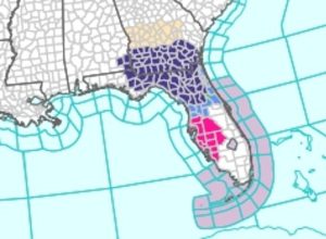
An urgent freeze warning has been issued for approximately 18 million Americans across the Southeast as temperatures are expected to plunge to record-breaking lows, with some areas seeing temperatures as low as 28°F.
Key Takeaways
- 18 million Americans under freeze warning through Wednesday
- Temperatures dropping to 28-30°F in Southeast regions
- Record lows expected across Florida and Southeast
- Coldest early-season system on record for the region
Affected Regions and Immediate Impacts
The National Weather Service has issued urgent warnings for southeast Alabama, the Florida Panhandle and Big Bend, north and northeast Florida, and south-central, southwest and southeast Georgia. The freeze warnings remain in effect until 8am ET on Thursday.
The NWS stated: ‘Appropriate action should be taken to ensure tender vegetation and outdoor pets have adequate protection from the cold temperatures. Young children, the elderly and the homeless are especially vulnerable to the cold. Take measures to protect them.’
Record-Breaking Cold System
This represents one of the strongest early-season high-pressure systems on record for the Southeast, bringing a deep pool of Arctic-modified air. AccuWeather meteorologists confirmed: ‘Cold air of Arctic origin is plunging southward from Canada into the eastern half of the United States, reaching as far as the Gulf Coast and Florida Panhandle early this week.’
Jacksonville, Florida may approach freezing temperatures Tuesday night, marking its coldest reading since February. Some locations are experiencing temperatures 20 to 25°F below historical averages for early November.
Unusual Florida Phenomena
The premature winter blast has already caused unusual effects in Florida, with reports of iguanas falling from trees due to cold paralysis. Cities as far south as Orlando and Tampa could tie record lows of 39 and 40 degrees respectively.
Infrastructure and Energy Concerns
The abrupt temperature drop threatens to send power demand soaring, disrupt supply chains, and damage unprotected infrastructure and plumbing. Forecasters warn this could be the first major test of the season for energy and utility systems.
In Atlanta, where the record low for Tuesday is 26 degrees, residents may need to drip faucets to prevent pipe damage as temperatures approach this threshold.
Western Shift and Snow Forecast
The NWS forecast shows the cold air shifting westward, with temperatures expected to drop dramatically across more than 10 states including California, Nevada, Arizona, New Mexico, Utah, Colorado, Idaho and Wyoming.
AccuWeather meteorologists warned that this Arctic shift could bring heavy snow to parts of California as soon as Thursday. ‘Temperatures are expected to drop sharply over the Sierra Nevada, allowing snow to accumulate quickly above the passes in northern areas,’ the AccuWeather team stated.
Areas including Lake Tahoe, Donner Pass, and the Sierra Nevada mountain range could see at least three inches of snowfall, with higher elevations receiving up to two feet by Thursday night.
Temperature Rebound Expected
The NWS forecasts temperatures should rise in the East, South and Midwest next week. A dome of warmer high pressure is expected to build in the Midwest and East, creating a dramatic temperature swing within days.
Illinois and Indiana have a 50 to 60 percent chance of seeing temperatures warm beyond their normal November average of 44 degrees, providing relief after recent storms that blanketed some areas with up to 12 inches of snow.


