


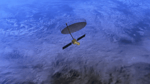
NISAR Satellite Beams First Stunning Images of India from Space
India’s groundbreaking NISAR satellite has transmitted its first high-resolution images of the Indian landmass, officially commencing science operations exactly 100 days after its historic launch.
Key Takeaways
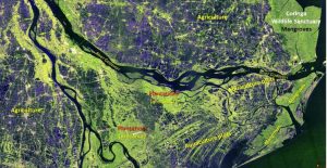
- First S-Band SAR images reveal Godavari River Delta with remarkable detail
- $1.5 billion satellite successfully deployed massive 12-meter antenna
- Mission will scan Earth every 12 days for climate and disaster monitoring
Historic First Images
The Indian Space Research Organisation publicly released the inaugural S-Band Synthetic Aperture Radar image capturing the lush Godavari River Delta in Andhra Pradesh. The image vividly displays mangroves, agricultural fields, arecanut plantations, and aquaculture ponds with unprecedented precision.
Complex Deployment Success
Launched aboard ISRO’s GSLV-F16 on July 30, 2025, from Sriharikota, the dual-frequency radar satellite overcame a challenging deployment process. NASA’s largest-ever Earth orbit antenna – a massive 12-meter diameter reflector mounted on a 9-meter boom – successfully unfurled over five days from August 9 to 15.
The intricate deployment involved wrist, shoulder, elbow, and root joints, managed jointly by ISRO’s ISTRAC in Bengaluru and NASA’s Jet Propulsion Laboratory. Both S-Band (ISRO) and L-Band (NASA) radars confirmed optimal performance.
Advanced Earth Monitoring Capabilities
Since its first data acquisition on August 19, NISAR’s S-Band has imaged India and global calibration sites in diverse modes. The satellite used corner reflectors near Ahmedabad, Gujarat, and Amazon rainforest data to fine-tune pointing accuracy.
Initial analyses demonstrate NISAR’s powerful capability to map dynamic landscapes like river deltas, even through cloud cover or during nighttime. Orbiting at 747 km in a sun-synchronous polar path, the satellite scans nearly all land and ice surfaces every 12 days, detecting centimeter-scale changes essential for:
- Disaster alerts and early warning systems
- Ecosystem and forestry tracking
- Climate change insights and monitoring
- Agricultural and hydrological studies
- Himalayan ice monitoring
This milestone solidifies the Indo-US space partnership, establishing NISAR as a transformative tool for global Earth observation amid increasing demand for precise environmental data.

