

")
Key Takeaways
- Indonesia recorded 1,400 earthquakes in 30 days, including a recent 6.3-magnitude quake near Sumatra
- The country sits on the Pacific Ring of Fire, where 90% of world’s earthquakes occur
- Recent seismic activity compounds ongoing flood disasters from Cyclone Senyar
A powerful 6.3-magnitude earthquake struck off Indonesia’s Sumatra island near Aceh province on November 27, 2025, adding to the nation’s mounting natural disasters. The shallow tremor, centered 63 km west of Sinabang at just 10 kilometers depth, caused brief panic but no immediate casualties or major damage.
This seismic event compounds Indonesia’s crisis as the country simultaneously battles deadly flash floods and landslides from Cyclone Senyar, which has killed over 25 people and left 10 missing in North Sumatra.
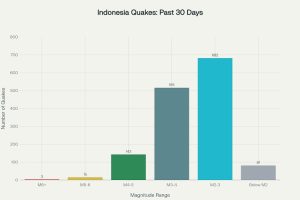
1,400 Earthquakes in 30 Days
Indonesia’s position on the Pacific Ring of Fire makes it one of the world’s most seismically active regions. Recent data reveals alarming numbers:
- 1,400 quakes recorded in the last 30 days
- Magnitudes reaching up to 6.4
- Approximately 250 significant events (M4.5+)
- 2,300 M4+ quakes in the past six months
These figures from USGS and VolcanoDiscovery highlight the intense tectonic activity characterizing the region.
Ring of Fire Vulnerability
Indonesia’s earthquake frequency stems from its location where 90% of the world’s quakes occur. The country lies at the convergence of 15 major tectonic plates, creating constant geological tension.
Sumatra specifically sits atop the Sunda megathrust, where the Indo-Australian Plate subducts beneath the Eurasian Plate at 5-7 cm annually. This continuous movement builds enormous stress that periodically releases through seismic events. Shallow quakes like the recent 6.3-magnitude tremor amplify ground shaking, significantly increasing risks in densely populated areas.
The Ring of Fire forms a horseshoe-shaped geological zone along Pacific Ocean edges, characterized by frequent earthquakes and tsunamis due to multiple tectonic plate boundaries.
Recent Seismic Swarm and Historical Context
Sumatra has experienced repeated tremors recently, including a 6.6-magnitude event nearby, linked to ongoing plate boundary strain and local faults like the Great Sumatra Fault.
The region remembers the devastating 2004 magnitude-9.1 earthquake that generated a tsunami killing 230,000 people across the Indian Ocean. While the current quake poses no tsunami threat, its timing exacerbates existing flood chaos with 8,000 people evacuated and roads blocked by debris in Sibolga and Central Tapanuli.
Authorities are monitoring aftershocks while urging public preparedness amid forecasts of additional flooding in Aceh and Riau from extreme weather. Indonesia’s disaster agency is coordinating helicopter aid deliveries, highlighting the dangerous interplay of geological and climatic hazards in this vulnerable archipelago.

