Google Maps Transforms Navigation in India with 10 AI-Powered Features
Google Maps is rolling out 10 significant updates specifically for Indian users, transforming the platform into a conversational AI-powered navigation assistant. The features range from Gemini AI integration in navigation to proactive traffic alerts and specialized safety warnings.
Key Takeaways
- Gemini AI now integrates directly into navigation for hands-free conversational assistance
- Proactive traffic and accident-prone area alerts enhance driving safety
- Real-time road closure data from NHAI improves route planning
- Customizable two-wheeler navatars and flyover voice guidance cater to Indian users
Conversational AI Navigation
Google Maps now integrates Gemini directly into navigation, allowing users to have natural conversations with the AI assistant while driving. You can ask questions like “nearest petrol pump” or “best restaurant nearby” and receive conversational responses that can add locations to your route.
“It isn’t just search. This is Gemini reasoning through a multi-step problem here,” said Lalitha Ramani, General Manager for Google Maps India.
The AI analyzes reviews, web content, and Maps community data to provide comprehensive information about places, including opening hours, parking availability, and price ranges.
Enhanced Planning and Exploration
Gemini now offers proactive local tips by analyzing user reviews and web content. The AI can suggest the best time to visit attractions, preview restaurant menus, and provide insider tips like bargaining advice or must-see spots.
Users can ask ultra-specific questions about locations, such as parking availability or must-visit stalls, with Gemini sifting through reviews, photos, and web data to find precise answers.
Advanced Safety Features
Google Maps introduces proactive traffic alerts that automatically warn users about major disruptions or delays on their route, even when not actively navigating. This feature initially rolls out in Delhi, Mumbai, and Bengaluru for major roads and highways.
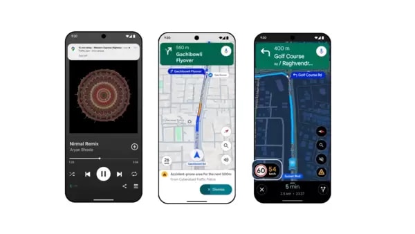
Accident-prone area alerts provide visual and voice warnings as drivers approach high-risk zones. Developed specifically for India in partnership with government authorities, this feature launches for Android users in Gurugram, Cyberabad, Chandigarh, and Faridabad.
Official Speed Limits and Road Data
Google now displays official speed limits from local traffic authorities next to the speedometer during navigation. Available on Android and iOS in nine cities including Faridabad, Ghaziabad, Gurugram, Hyderabad, Jaipur, Kolkata, Lucknow, Mumbai, and Noida.
Real-time road closure data from the National Highways Authority of India (NHAI) helps users avoid construction zones, with additional information about nearby amenities like restrooms, eateries, and petrol stations.
India-Specific Customizations
Two-wheeler users can now customize their navigation icon with eight different vehicle types and eight vibrant colors, rolling out nationwide on both Android and iOS.
Enhanced voice guidance for flyovers provides clearer, hands-free audio commands in nine Indian languages, particularly benefiting two-wheeler drivers who need to keep their eyes on the road.
Digital Ticket Integration
Users can now save booked tickets to Google Wallet with one click and access them directly through Google Maps. This feature is available for Android users in Delhi, Bangalore, Kochi, and Chennai, with Mumbai support coming soon.


