
Record-Breaking Polar Vortex Freezes US, 30 States Under Winter Alerts
A massive polar vortex is plunging the United States into a deep freeze, triggering winter weather warnings across 30 states. The National Weather Service has issued advisories from Maine to Nebraska, with wind chills making it feel as cold as -30°F in parts of the Midwest and Great Plains.
Key Takeaways
- Widespread Alerts: Winter weather warnings active in 30 states.
- Historic Cold: Temperatures forecast to drop 20°F below average, threatening decades-old records.
- Travel Chaos: Ice, snow, and a major 45-car pileup already disrupting roads and flights.
- Long Duration: Frigid air expected to last all week, reaching as far south as Tennessee.
Immediate Impacts and Forecast
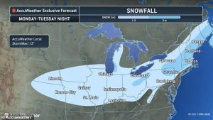
The heaviest snow is expected Monday night, with up to six inches possible from Ohio to New England. States like Iowa, Illinois, Indiana, and Michigan, still recovering from a Thanksgiving storm, will see temperatures in the single digits.
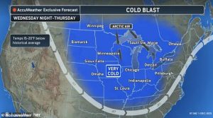
Meteorologists warn the Dakotas, Montana, Wyoming, Wisconsin, and Minnesota could see their coldest day of the year on Monday, with sub-zero readings. The cold is driven by a weakening polar vortex, a high-altitude whirlpool of Arctic air that has been destabilized, allowing the freeze to spill southward.
Expanding Danger: Ice and Record Lows
Ice warnings are in effect for parts of Maryland, Virginia, West Virginia, and North Carolina, creating hazardous conditions for Tuesday morning commutes. The polar vortex is projected to push into the South by mid-week, bringing record cold to Oklahoma, Arkansas, Missouri, and Tennessee.
AccuWeather warns temperatures in at least 20 states could fall up to 20 degrees below historical averages for early December. Iowa may see lows below -10°F on Thursday, breaking records held for decades. By Friday, record lows in the teens and 20s are forecast for , Chicago, Indianapolis, and Baltimore.
Travel Disruptions and Extended Outlook
The severe weather has already caused significant havoc. A 45-car pileup occurred Saturday on Interstate 70 in Indiana. The ongoing storms are expected to further impact ground and air travel, with some schools likely to close.
Climatologist Judah Cohen, a research scientist at MIT, told USA Today: ‘My thinking is that the cold the first week of December is the appetizer and the main course will be in mid-December.’
Cohen’s models suggest the most extreme cold could hit from the Canadian Plains to the U.S. East Coast in the third week of December. Meteorologist Ryan Maue notes the polar vortex will linger over Canada for 7-10 days.
Precipitation and Storm Details
A storm forming along a cold-warm air boundary will bring a mix of snow and sleet from Kansas to Pennsylvania Monday night into Tuesday. Ice buildup is likely in Oklahoma, Arkansas, Kentucky, Tennessee, and North Carolina.
Meanwhile, southern states from Virginia to Florida and eastern Texas face significant rainfall, thunderstorms, and flooding. The Catskills, Berkshires, and southeastern Maine could see up to 12 inches of snow.
In cities like New York and Philadelphia, snow may turn to rain on Tuesday, increasing slip hazards. A potential second storm could bring even more snow to New York later in the week.


