


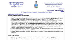
India is set to witness a spell of unsettled weather across several regions over the next few days, with thunderstorms, lightning and gusty winds forecast for parts of eastern, central and southern India. According to the latest bulletin issued by the India Meteorological Department (IMD) on February 23 at 07:45 pm, a low-pressure system over the Bay of Bengal, along with multiple upper-air circulations and troughs, is influencing weather conditions across the country.
As per the bulletin, some parts of Odisha, Jharkhand, West Bengal, Assam, Meghalaya, Chhattisgarh, Madhya Pradesh, Telangana and Vidarbha (in Maharashtra) may see short spells of rain, thunderstorms and gusty winds over the next day or two.

This does not mean nonstop heavy rain or flooding across the country. Instead, it suggests isolated thunderstorms in some areas, along with lightning and sudden strong winds. From around February 26, parts of Jammu & Kashmir, Himachal Pradesh, Uttarakhand, Kerala, Mahe, Arunachal Pradesh and Lakshadweep may see scattered rainfall activity.
Temperature rise in northwest, fluctuations elsewhere
The IMD has forecast a gradual rise in maximum temperatures by 2–3 degrees Celsius over northwest India during the next four days, with no significant change thereafter.
In contrast, Vidarbha and Chhattisgarh are likely to see a fall in maximum temperatures by around 2 degrees Celsius over the next three days, followed by a gradual increase of 2–3 degrees Celsius.
Elsewhere in the country, no significant change in maximum temperatures is anticipated.
Outlook for the week ahead
While thunderstorm activity will remain confined largely to eastern, central and island regions in the immediate term, weather conditions across most of northern and western India are expected to stabilise after February 26.
The anticipated weakening of the Bay of Bengal low-pressure system and the limited intensity of the incoming western disturbance suggest that widespread severe weather is unlikely in the coming days. However, residents in affected regions are advised to remain alert, particularly in areas prone to lightning and gusty winds.
With temperature fluctuations and isolated rainfall patterns continuing across various subdivisions, the transition toward pre-summer conditions appears gradual rather than abrupt.
Travel advisory
Travellers planning trips to Odisha, Jharkhand, West Bengal, Assam, Meghalaya, Chhattisgarh, Madhya Pradesh, Telangana and the Vidarbha region of Maharashtra should be prepared for short spells of rain, thunderstorms, lightning and sudden gusty winds over the next one to two days. The Andaman & Nicobar Islands may also experience thunderstorms and strong winds, which could temporarily affect boat rides, ferries and water activities.
While this is not a major storm or cyclone situation, brief thunderstorms can still lead to flight delays, slower road traffic and sudden drops in visibility.
Those travelling by air should check flight status in advance, especially in eastern and northeastern India, where weather-related disruptions are more likely during thunderstorms. Road travellers are advised to drive cautiously during heavy showers and avoid unnecessary travel during active lightning spells. From around February 26, light rain or snowfall may affect parts of Jammu & Kashmir, Himachal Pradesh and Uttarakhand, so visitors to the hills should carry warm clothing and check local road conditions before heading to higher altitudes.

