
Delhi woke up to light rainfall in the early hours of February 18 as an active Western Disturbance influenced weather conditions across northwest India. As per the India Meteorological Department’s latest bulletin (IMD), showers, isolated thunderstorms, gusty winds and hailstorm activity may continue across parts of north and central India over the next 24 hours.
The pre-dawn rain in Delhi led to cooler morning temperatures and partly cloudy skies, with intermittent gusty winds reported in several areas. According to the IMD forecast, wind speeds may reach 30–40 kmph in isolated pockets, particularly during thunderstorm activity. Maximum temperatures in the capital are likely to dip by 2–4 degrees Celsius before gradually rising later in the week. Minimum temperatures may fluctuate, initially rising slightly before falling again as the system moves eastward.
Western disturbances driving the weather shift
The rainfall over Delhi and adjoining regions is linked to active Western Disturbances affecting northwest India. One such disturbance, in the form of a cyclonic circulation, is positioned over central Pakistan and adjoining Punjab at around 3. 1 km above mean sea level. Another system over southeast Pakistan extends up to 7. 6 km above mean sea level, tilting northwestwards with height. An induced upper air cyclonic circulation persists over Punjab and its neighbourhood.

These systems are responsible for bringing cloud cover, light to moderate rainfall in isolated areas, and the potential for thunderstorms across Delhi, Haryana and Punjab. While rainfall in the capital has so far been light and scattered, adjoining states may witness more intense weather events.
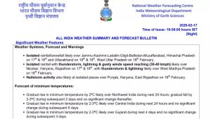
Hailstorm and thunderstorm alerts in neighbouring states
The IMD has forecast hailstorm activity at isolated places over Punjab, Haryana and East Rajasthan on February 18. Thunderstorms accompanied by lightning and gusty winds reaching 40–50 kmph are very likely over Haryana, Chandigarh and Punjab.
West Madhya Pradesh may also experience isolated thunderstorms and lightning. In Rajasthan, isolated lightning activity has been forecast, with some areas likely to witness gusty winds.
The IMD has advised residents in affected areas to avoid open fields during thunderstorms and to take precautions against lightning strikes and strong winds.
With Delhi already experiencing early morning rainfall and neighbouring states on alert for thunderstorms and hail, authorities have urged residents to stay updated with official forecasts and advisories as the weather system continues to influence conditions across north India.
Rain and snow in the hills
In the western Himalayan region, isolated rainfall and snowfall are likely over Jammu and Kashmir, Ladakh, and Himachal Pradesh on February 18. Uttarakhand is expected to receive similar precipitation through February 19, while West Uttar Pradesh may see isolated rainfall.
The combination of Western Disturbances and induced cyclonic circulations is contributing to widespread cloudiness and precipitation across the higher elevations, with spillover effects into adjoining plains.
Dense fog along the eastern coast
While north India experiences rain and thunderstorms, dense fog conditions are likely to persist during morning hours in isolated pockets over Odisha, coastal Andhra Pradesh and Yanam till February 19. Reduced visibility may disrupt transport services during early hours.
Temperature fluctuations across regions
The IMD has forecast a gradual rise in minimum temperatures by about 2 degrees Celsius over northwest India during the next 24 hours, followed by a fall of 2–3 degrees Celsius over the subsequent two days. Central India is likely to witness a 2–3 degrees Celsius rise in minimum temperatures over the next 24 hours, with no significant change thereafter.
Gujarat is expected to see a gradual rise in minimum temperatures over the next four days, while southern parts of Maharashtra may record a similar rise over the next two days. East India is likely to see stable minimum temperatures for three days before a gradual increase.
Maximum temperatures over the plains of northwest India are likely to fall by 2–4 degrees Celsius over the next two days, followed by a gradual rise. Gujarat, Maharashtra and Goa may not see significant change in maximum temperatures for the next three days.
Squally weather over sea areas
Squally weather conditions with wind speeds of 35–45 kmph, gusting to 55 kmph, are likely over many parts of the southwest Bay of Bengal and along and off the Sri Lanka coast through February 21. Similar conditions are expected over the Gulf of Mannar and Comorin area from February 19 onward. Fishermen have been advised to exercise caution while venturing into these areas.

