")
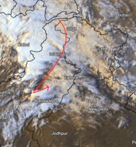
A significant weather shift is approaching India as a potent western disturbance, previously responsible for flooding in the Middle East, moves across the subcontinent.
According to the India Meteorological Department (IMD) and independent weather experts, peak activity is set for March 29 and 30, bringing a mix of intense rain, snow, and thunderstorms to several regions.

HOW WILL THE WEATHER BE IN INDIA TOMORROW?
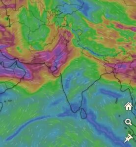
Devendra Tripathi, founder of Mausam Tak and weather vlogger for Kisan Tak, explains that the current atmospheric changes are driven by a unique convergence of moisture from three sides.
These are the Arabian Sea, the Bay of Bengal, and the moisture-laden winds brought in by the approaching western disturbance from the western Himalayan region.

He says that moisture flowing from the Arabian Sea and the Bay of Bengal will start to affect the central peninsula and the northern portion of Madhya Pradesh, and notes that the impact of these moist winds will increase the moisture content in the atmosphere across Maharashtra, Gujarat, Chhattisgarh, Odisha, and Uttar Pradesh.
Independent weather expert Navdeep Dahiya has issued a stark warning regarding the nature of this system. He notes that westerly jet streams, which led to flooding rains in Dubai, are likely to impact North India starting March 29.

Dahiya also warns that this trough will trigger dust storms, moderate to intense rains, and thundershowers.
While the spell on March 29 and 30 may provide a brief breather to some, he cautions that a more widespread crop killer spell is loading for April 3. He strongly advises farmers to harvest and store wheat crops immediately, as serious above-normal spring storms are expected over the next 15 days.
The IMD has issued a yellow alert for the northern hills, with Himachal Pradesh and Uttarakhand expected to witness light to moderate rainfall. In the plains, Punjab is likely to see the most intense activity.
Moderate to heavy thundershowers, wind gusts of 50 to 60 kmph, and hailstorms over parts of Punjab are expected to start tonight through tomorrow noon. Chandigarh is expected to see a spell of rain and thunderstorms between 9:00 and 13:00 IST on March 29.
Delhi and Haryana may only be marginally impacted on Sunday, with isolated spells of light rain expected between noon and evening.
However, the spread of thunderstorms and hail is predicted to increase significantly across Rajasthan, Delhi, Gujarat, and Uttar Pradesh by Monday, March 30.

In Central India, the IMD predicts isolated hailstorms over Madhya Pradesh, Vidarbha, and Chhattisgarh.
Devendra mentions that while the highest probability of rain remains in the north, clouds will be thick over Amritsar and Jalandhar. In the south, pre-monsoon activity might touch Telangana and Karnataka, though dry and hot conditions could still persist in many pockets.
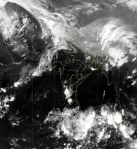
This evolving pattern, influenced by multiple cyclonic circulations, signals a volatile transition phase for the country.
With inputs from Anmol Nath Bali


