In Delhi, April already feels like August. The humidity is back, the heat is pressing in, and summer feels like it has arrived weeks early.
But something unusual is about to interrupt all of that.
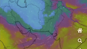
A powerful Western Disturbance, the kind of weather system North India normally sees in January, is sweeping in from the west, and by Tuesday, April 7, it could pull Delhi’s daytime temperature down from 35 degrees Celsius to as low as 21.
The system is now close enough to track in real time, and forecasters say its peak impact will be felt between April 7 and 10.
WHAT IS A WESTERN DISTURBANCE?
A Western Disturbance is an extratropical low-pressure system, which means it originates outside the tropics, typically over the Mediterranean Sea or the Atlantic Ocean.
It travels eastward, picking up moisture along the way, and eventually collides with the mountains and plains of northwest India, bringing rain, snow, and cooler air.
These systems are responsible for north India’s winter rainfall and snowfall in the hills, and they usually wind down by March.
When they arrive in April, they are considered unseasonal.
HOW IS THE SYSTEM BUILDING UP?
What makes this Western Disturbance particularly active is not just the system itself but what is feeding it.
Ample moisture from the Arabian Sea is fuelling a separate circulation forming over Rajasthan.
Think of this as a local whirlpool of warm, moist air that is building up cloud cover ahead of the main system approaching from the west.
The two are effectively working together, thickening the cloud band and enhancing rainfall potential across a wide stretch of north India.
Model visualisations show the low-pressure system positioned over Pakistan and Afghanistan, with moisture and wind vectors streaming steadily into northwest India.
The system will begin affecting West Rajasthan from the evening of April 6, spread across Punjab, Haryana, Delhi, and western Uttar Pradesh through April 7, and peak in intensity on April 8, before gradually weakening into April 10.
HOW COLD WILL IT GET ACROSS NORTH INDIA?
The temperature drop is expected to be striking. Current daytime highs across the plains sit at 33 to 35 degrees Celsius.
Forecasts from the ECMWF (European Centre for Medium Range Weather Forecasts), one of the world’s most accurate weather models, show maximum temperatures crashing to 19 to 24 degrees Celsius in Punjab, 20 to 25 degrees in Haryana, and 21 to 26 degrees in Delhi by April 7 and 8.
That is 8 to 15 degrees below the seasonal average. In practical terms, April will briefly feel like February.
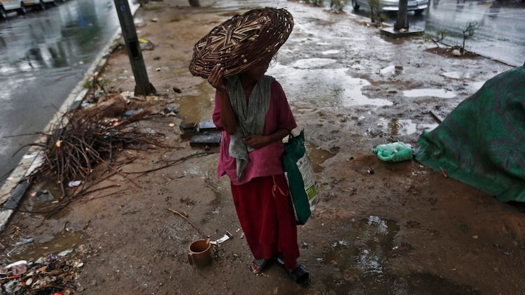
WILL THERE BE HAILSTORMS AND LIGHTNING?
Yes. The system is expected to trigger thundershowers, hailstorms, and lightning across several parts of North India on both April 7 and 8.
Hilly areas including Kashmir, Himachal Pradesh, and Uttarakhand will see moderate snowfall at higher elevations.

Separate convective activity, or localised, storm-driven weather bursts, is also forecast for Odisha, West Bengal, and parts of the northeast on the evening of April 6 itself.
WHAT DOES THIS MEAN FOR WHEAT FARMERS?
This is where the story turns serious. North India’s rabi wheat crop is at its harvest-ready stage, after what forecasters described as a strong growing season.
But multiple Western Disturbances arriving late in the season have already caused damage across farmlands.
This incoming system is stronger and covers a wider area than previous spells.
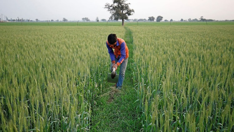
The additional moisture feed from the Arabian Sea circulation only amplifies the hail and rainfall risk.
Strong winds and hailstones at this stage can flatten standing crops, causing significant losses just before harvest.
Weather will begin improving from April 9, with no major disturbance expected for the next 10 to 15 days.


