


Key Takeaways
- 155+ million Americans under weather alerts as Arctic blast hits
- Temperatures could plunge to 15°F in coldest regions
- Record-breaking cold expected across Southeast, including Florida
- Heavy snow accumulating up to 18 inches in some areas
- Coldest early November outbreak in 32 years for Southeast
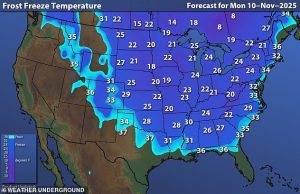
An intense Arctic blast is sweeping across the United States, placing over 155 million Americans under weather alerts from the Midwest to the Northeast. The National Weather Service has issued widespread freeze watches as temperatures threaten to break decades-old records.
Record-Breaking Cold Forecast
The coldest temperatures will hit parts of North Dakota, Minnesota, Wyoming and West Virginia, potentially dropping to 15°F. Multiple cities from Alabama to Georgia could shatter daily cold records, with freeze conditions extending as far south as Alabama’s Gulf Coast.
Even Florida isn’t escaping the deep freeze. Charleston is struggling to reach 50°F—about 20 degrees below average—while parts of central Florida will barely reach the 60s. Morning lows could plunge into the 20s along the Florida and Alabama Gulf Coast.
Matt Devitt, chief meteorologist at WINK News, issued an unusual warning: “The iguanas are not dead, just temporarily stunned and immobilized from the cold…especially if it drops below 45°. Only in Florida!”
Historic Cold Outbreak
This could be the coldest early November outbreak in Florida and the Southeast in 32 years, rivaling a November 1993 freeze event. The cold could challenge Veterans Day record lows in more than a dozen locations including Savannah, Georgia (31°F), Mobile, Alabama (31°F), and Ft. Myers, Florida (45°F).
Atlanta’s record low of 26 degrees might be matched, prompting residents to drip faucets overnight to prevent frozen pipes. Orlando and Tampa could tie record lows of 39°F and 40°F respectively.
Widespread Snow Accumulation
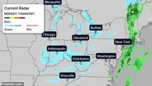
The Arctic blast is bringing the season’s first significant snowfall to many regions. Snow is already falling from Michigan’s Upper Peninsula to the Smoky Mountains, with heavy lake-effect snow accumulating across the Midwest and Great Lakes.
One intense snowband dumped up to 12 inches of snow in just six hours over Momence, Illinois, while buried areas south of Marquette, Michigan recorded 18 inches. Michigan’s Leelanau Peninsula saw up to 10 inches of accumulation.
Jonathan Porter, AccuWeather Chief Meteorologist, explained: “This storm pattern will introduce some of the coldest air seen for early November, and that is the reason for the robust snow amounts expected in the Great Lakes.”
Continuing Snow Threats
Snow will continue through Tuesday across multiple regions. The heaviest additional accumulations could occur in lake snowbelts from northwest Pennsylvania to New York’s Tug Hill Plateau, the Green Mountains of northern Vermont, and West Virginia’s Appalachians, where over six inches of snow is possible.
Several more inches could fall across the Ohio Valley and western Great Lakes snowbelts, affecting Michigan, Indiana, Ohio, northern Kentucky and the Smoky Mountains.


