

")
Key Takeaways
- Over 100 million Americans under cold weather warnings
- Temperatures dropping 10-30°F below normal across Midwest and East
- First snowfall expected in some areas weeks before Thanksgiving
- Detroit, Toronto, and Montreal could see up to a foot of snow
- Dangerous travel conditions expected from sudden snow squalls
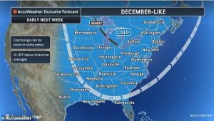
More than 100 million Americans are facing a severe cold outbreak this weekend, with December-like temperatures hitting the Midwest and Eastern United States. This significant temperature drop marks the most substantial cold spell since spring, bringing winter conditions weeks ahead of schedule.
Widespread Temperature Plunge
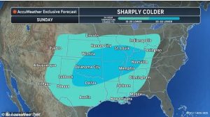
The middle US will experience a dramatic temperature decline starting Sunday. Cities like Nashville, Memphis, and St. Louis will see drops of 20-30°F, while Lexington, Kentucky and New Orleans will experience 10-20°F decreases. Atlanta is expected to reach only mid-40s on Monday – 20 degrees cooler than normal for this season.
Everywhere east of the Dakotas will face temperatures 10-15 degrees below average, with some areas experiencing their first snowfall just weeks before the Thanksgiving holiday.
Snow and Winter Conditions
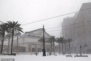
The Midwest and interior Northeast face the highest risk of turning into a “winter wonderland” between today and Tuesday. Some areas could see inches of snow, with Detroit having the highest chance of snowfall this week. Regions near Toronto and Montreal might receive up to a foot of snow.
Those in the Great Lakes region also face snow possibilities as cold air passes over water. Areas southeast of Lakes Ontario, Erie, and Hudson could see 3-6 inches of snow.
Dangerous Travel Conditions
AccuWeather vice president of forecast operations Dan DePodwin warned: ‘Along with the bands of lake-effect snow is the potential for briefly heavy snow squalls in portions of Ohio, Pennsylvania, western and central New York and northern West Virginia on Monday.’
He added: ‘While most of the snow will melt quickly on area roads, the sudden drop in visibility and temporary slush can create dangerous conditions on the highways.’
Weather System Origins
The cold spell originates from a change in the jet stream known as an Alberta clipper, moving from Canada through the Dakotas to the East Coast. Much colder air will plunge southward across the Great Plains and Mississippi Valley before moving eastward early next week.

