27.1 C
Delhi
Monday, March 2, 2026

Chandrayaan-2 Reveals Water Ice and Soil Secrets on Moon’s Poles

Key Takeaways

  • Chandrayaan-2’s orbiter has produced the first high-resolution L-band radar maps of the Moon’s poles.
  • The data reveals crucial details about potential water-ice deposits, surface roughness, and soil properties.
  • These findings are vital for planning future lunar missions and resource utilization.

India’s Chandrayaan-2 orbiter has delivered groundbreaking insights into the Moon’s polar regions, identifying potential water ice and detailed soil characteristics. Operating since 2019, the spacecraft’s radar has mapped the poles with unprecedented clarity.

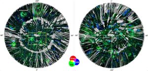
Scientists at ISRO’s Space Applications Centre (SAC) in Ahmedabad used data from the Dual Frequency Synthetic Aperture Radar (DFSAR) to create the first full-polarimetric, L-band radar maps at 25 meters per pixel resolution. This represents a major leap in lunar exploration capabilities.

Five Years of Data Collection

Over nearly five years, researchers processed approximately 1,400 radar datasets to generate detailed polar mosaics covering latitudes from 80 to 90 degrees in both hemispheres. The SAC team developed indigenous algorithms that provide key insights into:

  • Potential water-ice presence
  • Surface roughness variations
  • Dielectric properties indicating soil density and porosity

These parameters help characterize the Moon’s surface composition and hidden geological features beneath the surface.

Advanced Radar Measurements

The DFSAR data provides several critical measurements for lunar analysis:

  • Circular Polarisation Ratio (CPR): Sensitive to reflections from subsurface ice deposits
  • Single Bounce Eigenvalue Relative Difference (SERD): Quantifies surface roughness
  • T-Ratio: Correlates with dielectric constant, measuring how lunar regolith responds to electromagnetic waves

Polarimetric decomposition components (Odd, Even, Volume, and Helix) further reveal distinct radar scattering processes across different lunar terrains.

Scientific Impact and Availability

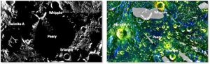
The Level-3C Polar Mosaic datasets have been released freely to the global scientific community. These findings are particularly significant for upcoming lunar missions as they provide first-order insights into thermal stability zones where water-ice could persist.

This information will aid future resource utilization and landing site selection. Beyond practical applications, the research deepens understanding of the Moon’s pristine polar environments, which may preserve some of the solar system’s earliest chemical signatures.

The synergy between Chandrayaan-2’s radar and hyperspectral datasets is expected to refine global models of lunar mineral distribution, advancing our knowledge of Earth’s celestial neighbor.

Latest

Bright Sun lights up Earth every day, then why is space so dark?

This new series from India Today Science explores the why and how behind everyday phenomena we notice, question, and often overlook. Each edition breaks down th

North India to stay hot and dry on Monday, cool morning to bring respite

India will face rising temperatures and cool mornings tomorrow. The IMD predicts a four to seven degrees Celsius rise in Northwest India.

Skyroot fires new rocket engine, makes diamonds in the air

Skyroot Aerospace has tested its Dhawan-III cryogenic engine, a 3D-printed marvel for reusable rockets. This breakthrough boosts India's space ambitions with gr

China races to land humans on Moon as Nasa revamps Artemis. All you need to know

China announces steady advances in its crewed Moon mission with successful tests on lunar spacecraft, and a detailed 2026 space station schedule.

Are crash diets worth the risk? How drastic weight loss ruins your skin tone and texture

The skin is one of the first places that shows the ill effects of drastic dieting. From dryness and dullness to premature ageing and breakouts, a crash diet can

Topics

Taliban attacks Pak’s Nur Khan base in latest escalation of cross border conflict

Taliban forces reportedly launched armed drone strikes targeting Pakistan’s Command and Control Centre at Nur Khan Air Base in Rawalpindi. Taliban forces carr

Satellite images show damage across Iranian military sites after US-Israel strikes

Fresh satellite imagery shows visible damage to air, drone and naval facilities near Iran’s Konarak region amid escalating regional tensions. The visuals offe

Sensex down 1,000 points: Why is the stock market falling today?

The S&P BSE Sensex fell sharply in early trade, and the NSE Nifty50 also slipped more than 1%, as investors reacted to the fast-changing situation between the U

Qatar, UAE, Syria, Oman: Full list of places that saw attacks amid US-Iran conflict

The Middle East is engulfed in conflict as Iran retaliates against US-Israeli strikes, launching missile and drone attacks across multiple countries. 

AIIMS-trained neurologist warns against repeatedly using reheated cooking oils: ‘Risk of cancer increases manifold…’

Reusing cooking oil is a common practice in many households, but does the money it saves outweigh the health risks? Dr Sehrawat explains the health risks.

Quote of the day by Jon Bon Jovi: ‘You better stand tall when they’re calling you out, don’t bend, don’t break…’

On his birthday, we look back at one of Jon Bon Jovi's most influential quotes, which highlights the importance of standing tall in the face of criticism.

Satellite images show black smoke over Dubai as Iran continues to fire missiles, drones

Iran-US war: Dubai's skyline has dramatically changed after Iranian attacks, with smoke visible in satellite images.

Sam Altman reveals real reason why OpenAI rushed to partner with US Military after Trump banned Anthropic

OpenAI executives have given more information regarding the AI startup’s contract with the US Department of Defense after facing backlash online. The Sam Altm
spot_img

Related Articles

Popular Categories

spot_imgspot_img